File(s) | Type | Description | Action |
---|---|---|---|
broadscale_grid.csv (76.73 KB) | Comma Separated Values (.csv) | Primary data file for dataset ID 2296 | Add to Cart Download |
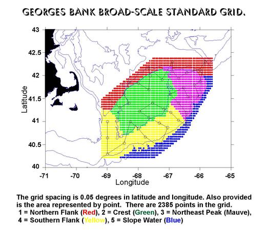
Grid developed for Broad-scale gridding in the Georges Bank and Gulf of Maine area (GB project)
The Broad-scale grid is defined by the points within this data file. It is used for Broad-scale gridding applications. Each rectangle in the grid is 0.05 degrees latitude by 0.05 degrees longitude. The area is the area, in km2, that the grid point represents. The field names are as follows:
For information relating to the development of the grid, see the Grid Report
This is an example of a gridding datasheet.
Download Excel File. (Hold SHIFT key and Click to download)
Note: Subregion 5 (Slope Water) has been redefined to include those points formerly in Subregion 3 (Northeast Peak) where the water is deeper than 150 meters.
Last modified: June 16, 2004
Wiebe, P. (2004) Grid developed for Broad-scale gridding in the Georges Bank and Gulf of Maine area (GB project). Biological and Chemical Oceanography Data Management Office (BCO-DMO). (Version 1) Version Date 2004-06-16 [if applicable, indicate subset used]. doi:10.1575/1912/bco-dmo.2296.1 [access date]
Terms of Use
This dataset is licensed under Creative Commons Attribution 4.0.
If you wish to use this dataset, it is highly recommended that you contact the original principal investigators (PI). Should the relevant PI be unavailable, please contact BCO-DMO (info@bco-dmo.org) for additional guidance. For general guidance please see the BCO-DMO Terms of Use document.